
Resource Links
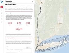
Ocean Reports
Reports include descriptive infographics and supporting data that can be used for offshore planning, permitting, environmental review, public relations, and more. New features allow printing by industry, sharing, and adding custom coordinates.
NOAA Institutional Repository
The NOAA Repository is a digital library of scientific literature and research produced by the National Oceanic and Atmospheric Administration. Through curated collections researchers can access documents and materials related to specific areas of research. Additionally, full text and other search options make the entirety of the repository accessible to users. This repository is retained indefinitely available to researchers, academics and the general public.
Digital Coast
Dive into the Digital Coast to Get the Data, Tools, and Training Communities Need to Address Coastal Issues.

NOAA Voices
Voices is an open-access repository of qualitative data in the form of oral history interviews related to the NOAA Mission.
Voices provides NOAA staff, researchers, educators, communicators and others seeking access to profoundly immersive and contextualized information on the human experience and the environmental data record.
Available data can be searched by location or by keyword/topic.
Marine Biodiversity Observation Network (MBON)
The Marine Biodiversity Observation Network (MBON) is a growing global initiative composed of regional networks of scientists, resource managers, and end-users working to integrate data from existing long-term programs to improve our understanding of changes and connections between marine biodiversity and ecosystem functions.
Interagency Ocean Observation Committee
The 34 IOOS Core Variables: Ocean observing measurements required to detect and predict changes in the ocean
The Global Ocean Observing System
This Framework is designed to approach ocean observations with a focus on Essential Ocean Variables, ensuring assessments that cut across platforms and recommend the best, most cost effective plan to provide an optimal global view for each EOV.
NOAA Integrated Ecosystem Assessment Program
National Oceanic and Atmospheric Administration (NOAA) Integrated Ecosystem Assessments (IEA) are an approach to Ecosystem-Based Management. This approach integrates all components of an ecosystem, including humans, into the decision-making process so that managers can balance trade-offs and determine what is more likely to achieve their desired goals. The approach is a NOAA-wide initiative, that provides a consistent national approach but is flexible to accommodate regional needs. It is overseen by the IEA program, which directs the execution of Integrated Ecosystem Assessments within five regions in the United States ocean and coastal ecosystems.
National Marine Sanctuaries
NOAA's Office of National Marine Sanctuaries serves as the trustee for a network of underwater parks encompassing more than 600,000 square miles of marine and Great Lakes waters. The network includes a system of 14 national marine sanctuaries and Papahānaumokuākea and Rose Atoll marine national monuments.
U.S. Global Change Research Program
The U.S. Global Change Research Program (USGCRP) is a Federal program mandated by Congress to coordinate Federal research and investments in understanding the forces shaping the global environment, both human and natural, and their impacts on society. USGCRP facilitates collaboration and cooperation across its 13 Federal member agencies to advance understanding of the changing Earth system and maximize efficiencies in Federal global change research.
Together, USGCRP and its member agencies provide a gateway to authoritative science, tools, and resources to help people and organizations across the country manage risks and respond to changing environmental conditions.
National Centers for Environmental Information
The demand for high-value environmental data and information has dramatically increased in recent years. To improve our ability to meet that demand, NOAA's former three data centers—the National Climatic Data Center, the National Geophysical Data Center, and the National Oceanographic Data Center, which includes the National Coastal Data Development Center—have merged into the National Centers for Environmental Information (NCEI).
NCEI is responsible for hosting and providing access to one of the most significant archives on Earth, with comprehensive oceanic, atmospheric, and geophysical data. From the depths of the ocean to the surface of the sun and from million-year-old sediment records to near real-time satellite images, NCEI is the Nation's leading authority for environmental information.

Climate.gov
NOAA Climate.gov provides science and information for a climate-smart nation. Americans’ health, security, and economic well-being are closely linked to climate and weather. People want and need information to help them make decisions on how to manage climate-related risks and opportunities they face.
NOAA Climate.gov is a source of timely and authoritative scientific data and information about climate. Our goals are to promote public understanding of climate science and climate-related events, to make our data products and services easy to access and use, to provide climate-related support to the private sector and the Nation’s economy, and to serve people making climate-related decisions with tools and resources that help them answer specific questions.
Climate Program Office
To predict the weather — including extreme events — we have to understand both climate variability and change. NOAA OAR’s Climate Program Office (CPO) advances understanding and prediction of climate, and leverages the science to help Americans plan and respond. CPO is never policy prescriptive — CPO’s information doesn’t tell us what to do; rather, it tells us what has happened, what’s likely to happen, why, and with what impacts. CPO’s work underpins and supports the development of the quadrennial U.S. National Climate Assessment, which was mandated by Congress in the Global Change Research Act of 1990.

Economic National Ocean Watch data base
The Economics: National Ocean Watch (ENOW) data set features time-series data focused on the six economic sectors that are dependent on the oceans and Great Lakes. ENOW is available for counties, states, regions, and the nation in a wide variety of formats.
NOAA Ocean Acidification Program (OAP)
NOAA's Ocean Acidification Program seeks to better prepare society to respond to changing ocean conditions and resources by expanding understanding of ocean acidification, through interdisciplinary partnerships, nationally and internationally. Ocean acidification is occurring because our ocean is absorbing carbon dioxide from the atmosphere, leading to lower pH and greater acidity. This is causing a fundamental change in the chemistry of the ocean from pole to pole.
NOAA Ocean Acidification Data Stewardship (OADS)
Ocean Acidification Data Stewardship (OADS) is a data management project funded by NOAA/OAR/Ocean Acidification Program (OAP), and operated within NOAA's National Centers for Environmental Information (NCEI). The primary mission of OADS is to ensure all data collected from OAP investments are properly archived and made accessible towards improved assessments of marine ecosystem vulnerability, and better forecasting capabilities, in accordance with the NOAA Plan for Public Access to Research Results (PARR) and the White House executive order on making data open and machine readable.
Green Infrastructure Effectiveness Database
Search this online database of literature sources containing information on the effectiveness of green infrastructure to reduce the impacts of coastal hazards, such as inundation and erosion from tropical storms and cyclones, more frequent precipitation events, and sea level rise. The database contains records from a wide range of sources, such as peer-reviewed journals, online tools, and gray literature, and includes information on 32 different coastal green infrastructure types. The green infrastructure techniques referenced cover a full range of approaches to coastal management, including natural, nature-based (e.g., low-impact development), structural, and policies.
State of the Great Lakes Report
Pursuant to the Great Lakes Water Quality Agreement, Canada and the United States, together with their many partners, have established a suite of 9 indicators of ecosystem health to assess the state of the Great Lakes. The assessment is made based on indicators such as drinking water, fish consumption, and beach closures. Over 180 government and non-government Great Lakes scientists and other experts worked to assemble available data and prepare the report.

Atlantic Highly Migratory Species Stock Assessment and Fisheries Evaluation Reports
NOAA Fisheries produces an annual Stock Assessment and Fisheries Evaluation (SAFE) Report that reviews the current status of Atlantic HMS fish stocks (tunas, swordfish, billfish, and sharks) and describes the year’s fishery management accomplishments. The report—required under the Magnuson-Stevens Fishery Conservation and Management Act—provides the public with information on the latest developments in Atlantic HMS management.
NOAA Habitat Focus Areas
The NOAA Habitat Focus Areas (HFAs) are targeted places where NOAA focuses its programs and investments to address a high priority habitat issue by working with partners and communities. The HFAs are tangible examples of the NOAA Habitat Blueprint.