Indicator Highlight: Sea Level
- Anonymous
- |
- |
- 25 Comments
Picture this – You’re 7 years old and on summer vacation. You’ve travelled with your family to North Carolina’s coastal barrier islands, the Outer Banks, home to your family’s beach house. The sun is shining as you stand on the porch overlooking the beach. The ocean breeze fills your nose with salty air and nourishes your soul. The ocean calls your name and you sprint down the stairs onto the white sands and run into the Atlantic Ocean.
Later, you’re 30 years old and on summer vacation at the same family beach house. It’s your first trip to the house in years. You stand on the porch and can feel the ocean mist on your face as your child makes sand castles on the narrowing beach and the sun sets behind you.

Source: NOAA Photo Library
Now, you’re 75 years old and on summer vacation at the beach house in the Outer Banks that you now own, passed down through your family for generations. Your child and their family are unable to visit this year due to safety concerns – the town has mailed you a letter notifying you that the beaches have eroded and the land that your house sits on is unstable. The daily tides, and rising sea level, have washed away the beachfront property that held so many memories. How could this happen?
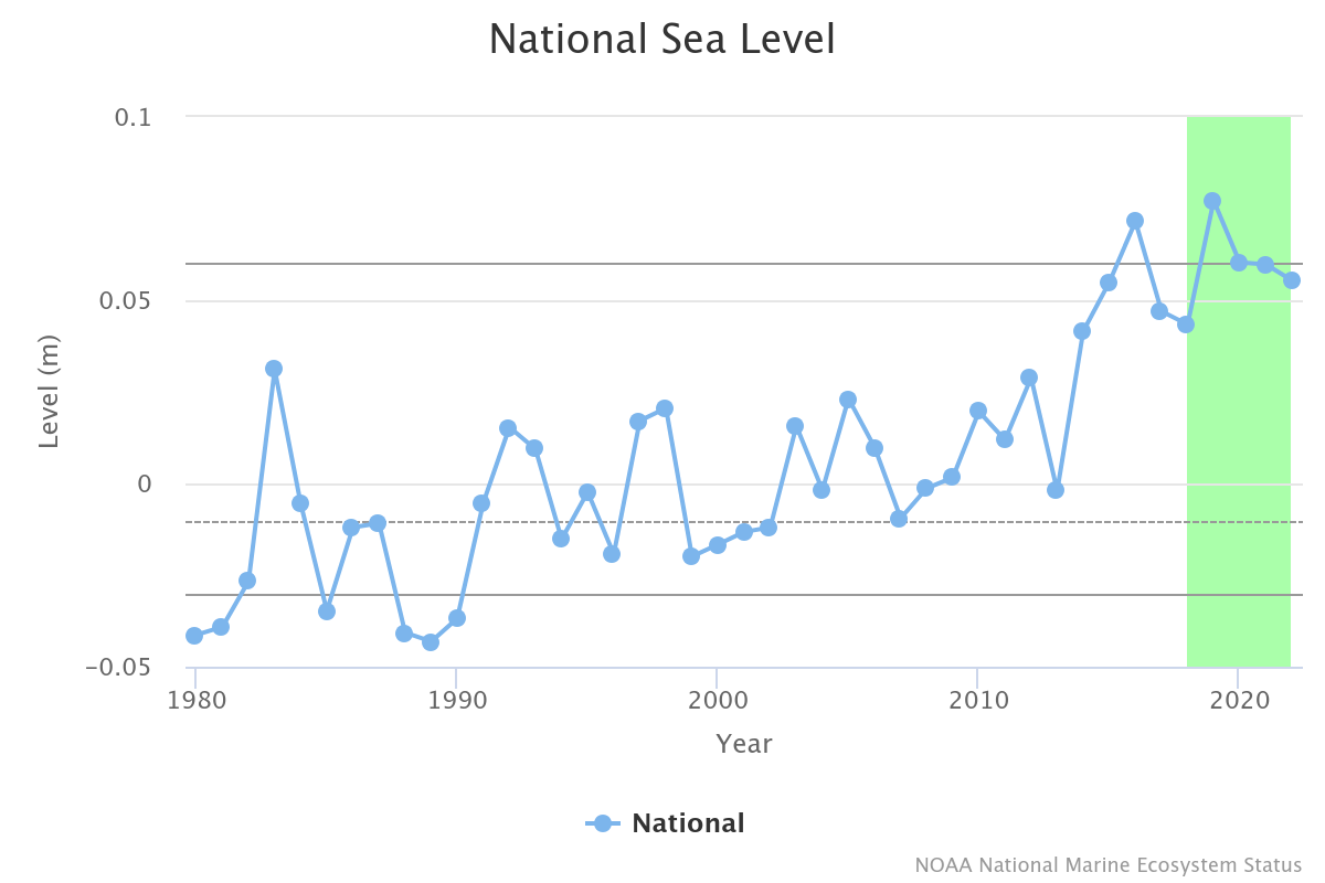
Sea levels define a strict boundary between terrestrial and aquatic habitats. We are familiar with measuring the rise and fall of coastal tides on a daily basis, but scientists also measure long-term sea level trends. While these levels may appear relatively static during our lifetime, small changes over generations can have major impacts on coastal human communities, and large changes can completely change the ecosystems on the land you’re standing on right now.
What is Sea Level, how is it measured?
Sea Level is defined as the average height of the ocean relative to a specific point on land. Just like how the earth has hills and valleys, the ocean has high and low points too. On NaMES, each Large Marine Ecosystem’s mean annual sea level is calculated using an average of well-maintained gauges in the region. An alternative method, which NOAA also calculates, uses satellite altimetry, or measurements of the water height from satellite sensors, to track changes to sea level across the entire region.
Sea level can be measured and tracked locally as well as globally. Changes in local sea level can be driven by phenomena like land subsidence (a gradual settling or sudden sinking of the Earth's surface), ocean currents, gravitational forces, and differences in land height. Global sea level can be affected by larger scale processes like expansion of warming water or melting of land-based ice like glaciers and ice sheets. These drivers vary over time and location, which is why it’s important to use as much data as possible to measure averages or changes to sea level.
Why do we track changes to Sea Level?
We track sea level to understand natural coastal dynamics, navigational safety, and economic impacts, and to better prepare our coastal communities to be resilient to changing ocean conditions. Both increases and decreases in sea level can affect coastal habitats, ecosystems, and man-made infrastructures. Rising sea level can flood low-lying coastal areas, increasing the number of damaging flooding events, eroding shorelines, and altering navigational conditions.
Sea level rise in coastal habitats can increase the amount of salt water moving into estuarine and freshwater ecosystems. The increase in saline (salty) water may stress native plants and animals that are adapted to less saline environments, which can cause declines in animal condition and habitat quality. Rising sea levels can also decrease the efficacy of common man-made structures like jetties and sea walls that were built to protect coastal communities from erosion and wave damage. By tracking local rises in sea level, we can better understand changes in numerous aquatic plant and animal species in response to changing habitat salinity, and we can build effective infrastructure to protect our coastal communities from water and wave damage.
Navigational safety and operations can also be affected by rising sea levels, resulting in altered conditions that could increase the risk of vessel incidents. Rising sea levels can lead to increased flooding of port facilities, changes in water currents and depths, and altered coastal routes, such as shifts in sand bars, natural channels, and destruction of jetties. Impacts to vessel operations can impact people across the country by disrupting global supply chains leading to economic losses.
How could Sea Level affect me?
If you ever visited a seaside town you have probably seen high tides, with seawater close to the shore, and low tides, with large expanses of exposed damp sand and tide pools. On a daily basis, high and low tides influence things like safe access to ports and harbors and beaches.
Less frequently, big storms that produce strong winds (e.g. hurricanes or Nor'easters) can cause coastal waters to rise above a normal high tide creating storm surge. When storm surge floods human-made infrastructure, it can have many negative impacts on coastal communities such as loss of life, coastal erosion, and damage to buildings, roads or utilities.

High tide flooding April 12, 2024, blocks businesses in Annapolis, Maryland. (Credit: NOAA)
Large-scale damage may close beaches, and decrease coastal tourism, fishing engagement and opportunities for coastal employment. As marine coastal populations increase, these impacts may become worse. Natural resources such as estuaries, marshes, wetlands, and freshwater bodies and aquifers may be damaged by saltwater intrusion. When accompanied by rainfall, storm surge can diminish storm water drainage, leading to worsening inland flooding in low-lying areas, and along creeks and rivers.
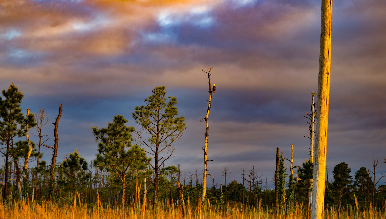
Ghost forest where rising seas have killed off freshwater-dependent trees in North Carolina. Photo NOAA Seagrant
Displacement of coastal communities results from sea level rise making the land uninhabitable due to increased frequency of flooding as well as long-term high water levels. Industries, such as commercial and recreational fisheries, rely on access to coastal infrastructure such as shipping ports, piers, marinas, and docks, so they may suffer economic losses. Recreational businesses and seaside communities that rely on coastal tourism and access to healthy coastal ecosystems (fisheries, coral reefs, beaches) will also suffer economic losses. Government agencies charged with the protection of our national waters and coasts (Navy, Coast Guard) rely on access to coastal facilities to maintain capabilities related to ocean-going vessels, meaning they are also vulnerable to changes in sea level.
Conclusion
Whether measured locally by tidal gauge or globally by satellite, we know that sea levels continue to change. We track changes in sea level so that we can understand and prepare our coastal communities, providing resiliency along our coastlines. As long as our oceans continue to shift, and the land beneath our feet slowly rises or sinks, sea level will continue to change too.
Read more: