
Description of Coral Reefs:
Coral reefs are some of the most diverse and valuable ecosystems on Earth. Though they cover less than one percent of the Earth’s surface, they are estimated to provide ecosystem services (economic and environmental services) worth hundreds of billions of dollars each year. Healthy reefs protect islands and coasts from storm surge, contribute to local economies through tourism (i.e., sportfishing, snorkeling, and diving), and contribute about one-quarter of the total fish catch, providing critical food resources for tens of millions of people particularly in developing island nations.
Data Source:
The coral reef ecosystem scores shown here were analyzed using data from the National Coral Reef Monitoring Program (NCRMP). The scores and labels you see for each region are composite scores for all four themes (benthic, fish, climate, human connections) assessed separately and then one overall score. The overall score is an average of all four theme scores for a specific region’s coral reef ecosystem score. The sources for these values and geographical regions are obtained from the NCRMP’s Status Report Scoring Methodology for Pacific Jurisdictions and 2020 Status Report Scoring Methodology for Atlantic Jurisdictions. The definitions for the themes are as follows:
- Benthic (Corals & algae): Corals and algae make up the base of the coral reef ecosystem, providing food and shelter for fish and other marine animals.
- Fish: Coral reefs serve a vital ecological role for fish species. Fish are important to the ecology of the reef, the economy, and the livelihoods of local communities.
- Climate: Climate affects all components of a reef system. Climate change and ocean acidification influence reefs across the globe, but conditions vary at the regional and local level.
- Human Connections: Coral reef management agencies protect reef resources through management plans, public education, and involving communities in managing their resources.
If you want to learn more about the technical aspects of how we scored U.S. coral reefs, check out this paper in Frontiers in Marine Science:
For the most up to date data, please reference the original source above.
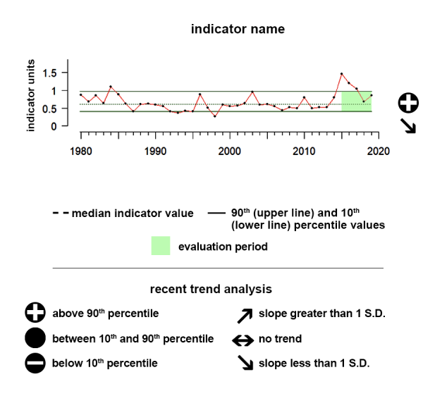
Understanding the Time series plots
Time series plots show the changes in each indicator as a function of time, over the period 1980-present. Each plot also shows horizontal lines that indicate the median (middle) value of that indicator, as well as the 10th and 90th percentiles, each calculated for the entire period of measurement. Time series plots were only developed for datasets with at least 10 years of data. Two symbols located to the right of each plot describe how recent values of an indicator compare against the overall series. A black circle indicates whether the indicator values over the last five years are on average above the series 90th percentile (plus sign), below the 10th percentile (minus sign), or between those two values (solid circle). Beneath that an arrow reflects the trend of the indicator over the last five years; an increase or decrease greater than one standard deviation is reflected in upward or downward arrows respectively, while a change of less than one standard deviation is recorded by a left-right arrow.
Hawai'i - Main Hawaiian Islands
The Main Hawaiian Islands coral reefs score 71, meaning some indicators meet reference values.

Data Interpretation:
The scores you see for each region are composite scores for the themes and then one overall score. The overall score is an average of all four theme scores for the Main Hawaiian Islands region’s coral reef ecosystem score.
Benthic – Composite gauge for benthic theme score in the Main Hawaiian Islands region is 65%, meaning it is ranked impaired with very few indicators meeting reference values.
Fish – Composite gauge for fish theme score in the Main Hawaiian Islands region is 66%, meaning it is ranked impaired with very few indicators meeting reference value.
Climate – Composite gauge for climate theme score in the Main Hawaiian Islands region is 70%, meaning it is ranked fair with some indicators meeting reference values.
Human connections – Composite gauge for human connections theme score in the Main Hawaiian Islands region is 81%, meaning it is ranked good with most indicators meeting reference values.
Overall Ecosystem – Overall coral reef ecosystem score for the Main Hawaiian Islands region is 71%, meaning it is ranked fair with some indicators meeting reference values.
Description of each theme is provided in the indicator information section below.
Gauge values
90–100% Very good: All or almost all indicators meet reference values.
80–89% Good: Most indicators meet reference values.
70–79% Fair: Some indicators meet reference values.
60–69% Impaired: Few indicators meet reference values.
0–59% Critical: Very few or no indicators meet reference values.
Description of Main Hawaiian Islands
The Hawaiian Archipelago includes the state of Hawai‘i and the Northwestern Hawaiian Islands. The archipelago consists of volcanic islands, atolls, and seamounts that stretch over 1,500 miles from southeast to northwest. The NCRMP status report has two main Hawaiian regions, the Main Hawaiian Islands (the State of Hawai‘i) and the Northwestern Hawaiian Islands. The Main Hawaiian Islands are inhabited islands in the Pacific Ocean. The Islands consist of eight volcanic islands surrounded by coral reefs. The Main Hawaiian Islands were further subdivided into four regions based on geographic location and data availability. The four regions are O‘ahu, Hawai‘i, Maui Nui, and Kaua‘i and Ni‘ihau. The total coral reef hardbottom habitat less than 30 m in depth that was monitored is 974 sq km
Hawai'i - Northwest Hawaiian Islands
The Northwest Hawaiian Islands coral reefs score 76, meaning some indicators meet reference values.
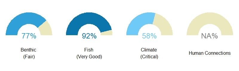
Data Interpretation:
The scores you see for each region are composite scores for the themes and then one overall score. The overall score is an average of all four theme scores for the Northwestern Hawaiian Islands region’s coral reef ecosystem score.
Benthic – Composite gauge for benthic theme score in the Northwestern Hawaiian Islands region is 77%, meaning it is ranked fair with some indicators meeting reference values.
Fish – Composite gauge for fish theme score in the Northwestern Hawaiian Islands region is 92%, meaning it is ranked very good with all or almost all indicators meeting reference value.
Climate – Composite gauge for climate theme score in the Northwestern Hawaiian Islands region is 58%, meaning it is ranked critical with very few indicators meeting reference values.
Human connections – Human connections theme was not scored for Northwestern Hawaiian Islands region because the region is uninhabited.
Overall Ecosystem – Overall coral reef ecosystem score for the Northwestern Hawaiian Islands region is 76%, meaning it is ranked fair with some indicators meeting reference values.
Description of each theme is provided in the indicator information section below.
Gauge values
90–100% Very good: All or almost all indicators meet reference values.
80–89% Good: Most indicators meet reference values.
70–79% Fair: Some indicators meet reference values.
60–69% Impaired: Few indicators meet reference values.
0–59% Critical: Very few or no indicators meet reference values.
Description of Northwest Hawaiian Islands
The Northwestern Hawaiian Islands are the mostly uninhabited northwestern three quarters of the Hawaiian Archipelago stretching 1,350 miles. They are completely encompassed within the Papahānaumokuākea Marine National Monument and include coral islands, seamounts, banks, and shoals. The total coral reef hardbottom habitat less than 30 m in depth that was monitored is 911 sq km.
American Samoa
The American Samoa coral reefs score 80, meaning most indicators meet reference values.

Data Interpretation:
The scores you see for each region are composite scores for the themes and then one overall score. The overall score is an average of all four theme scores for the American Samoa region’s coral reef ecosystem score.
Benthic – Composite gauge for benthic theme score in the American Samoa region is 82%, meaning it is ranked good with most indicators meeting reference values.
Fish – Composite gauge for fish theme score in the American Samoa region is 73%, meaning it is ranked fair with some indicators meeting reference values.
Climate – Composite gauge for climate theme score in the American Samoa region is 77%, meaning it is ranked fair with some indicators meeting reference values.
Human connections – Composite gauge for human connections theme score in the American Samoa region is 88%, meaning it is ranked good with most indicators meeting reference values.
Overall Ecosystem – Overall coral reef ecosystem score for the American Samoa region is 80%, meaning it is ranked good with most indicators meeting reference values.
Description of each theme is provided in the indicator information section below.
Gauge values
90–100% Very good: All or almost all indicators meet reference values.
80–89% Good: Most indicators meet reference values.
70–79% Fair: Some indicators meet reference values.
60–69% Impaired: Few indicators meet reference values.
0–59% Critical: Very few or no indicators meet reference values.
Description of American Samoa
American Samoa is an unincorporated United States Territory in the South Pacific. The Territory consists of five volcanic islands and two atolls, all of which are surrounded by fringing coral reefs. American Samoa was divided into six regions based on geographic location and data availability. The six regions are North Tutuila, South Tutuila, Ta‘u, Swains Island, Ofu and Olosega, and Muliava (Rose Atoll). The total coral reef hardbottom habitat less than 30 m in depth that was monitored is 62 sq km.
Guam
The Guam coral reefs score 71, meaning some indicators meet reference values.
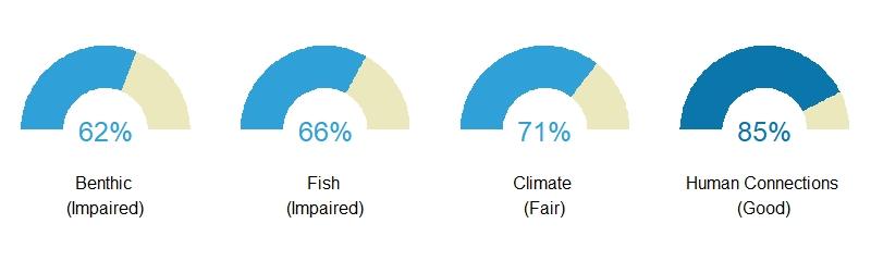
Data Interpretation:
The scores you see for each region are composite scores for the themes and then one overall score. The overall score is an average of all four theme scores for the Guam region’s coral reef ecosystem score.
Benthic – Composite gauge for benthic theme score in the Guam region is 62%, meaning it is ranked impaired with very few indicators meeting reference values.
Fish – Composite gauge for fish theme score in the Guam region is 66%, meaning it is ranked impaired with very few indicators meeting reference values.
Climate – Composite gauge for climate theme score in the Guam region is 71%, meaning it is ranked fair with some indicators meeting reference values.
Human connections – Composite gauge for human connections theme score in the Guam region is 85%, meaning it is ranked good with most indicators meeting reference values.
Overall Ecosystem – Overall coral reef ecosystem score for the Guam region is 71%, meaning it is ranked fair with some indicators meeting reference values.
Description of each theme is provided in the indicator information section below.
Gauge values
90–100% Very good: All or almost all indicators meet reference values.
80–89% Good: Most indicators meet reference values.
70–79% Fair: Some indicators meet reference values.
60–69% Impaired: Few indicators meet reference values.
0–59% Critical: Very few or no indicators meet reference values.
Description of Guam
Guam is an unincorporated territory of the US in the western Pacific Ocean. It is the largest and southernmost island of the Mariana Archipelago. Guam was divided into three sub-regions consisting of Western Guam, Eastern Guam, and the marine protected areas of Guam. The total coral reef hardbottom habitat less than 30 m in depth that was monitored is 51 sq km
Northern Mariana Islands
The Northern Mariana Islands coral reefs score 78, meaning some indicators meet reference values.

Data Interpretation:
The scores you see for each region are composite scores for the themes and then one overall score. The overall score is an average of all four theme scores for the Northern Mariana Islands region’s coral reef ecosystem score.
Benthic – Composite gauge for benthic theme score in the Northern Mariana Islands region is 71%, meaning it is ranked fair with some indicators meeting reference values.
Fish – Composite gauge for fish theme score in the Northern Mariana Islands region is 76%, meaning it is ranked fair with some indicators meeting reference values.
Climate – Composite gauge for climate theme score in the Northern Mariana Islands region is 69%, meaning it is ranked impaired with very few indicators meeting reference values.
Human connections – Composite gauge for human connections theme score in the Northern Mariana Islands region is 97%, meaning it is ranked very good with all or almost all indicators meeting reference value.
Overall Ecosystem – Overall coral reef ecosystem score for the Northern Mariana Islands region is 78%, meaning it is ranked fair with some indicators meeting reference values.
Description of each theme is provided in the indicator information section below.
Gauge values
90–100% Very good: All or almost all indicators meet reference values.
80–89% Good: Most indicators meet reference values.
70–79% Fair: Some indicators meet reference values.
60–69% Impaired: Few indicators meet reference values.
0–59% Critical: Very few or no indicators meet reference values.
Description of Northern Mariana Islands
Located just north of Guam in the Western Pacific, the Northern Mariana Islands is a 300-mile archipelago consisting of 14 islands. Data for the Northern Mariana Islands status report were from four sub-regions: Rota, Saipan,Tinian, andAguijan, Northern Islands, and National Monument. The total coral reef hardbottom habitat less than 30 m in depth that was monitored is 105 sq km
Pacific Remote Islands
The Pacific Remote Islands coral reefs score 82, meaning most indicators meet reference values.
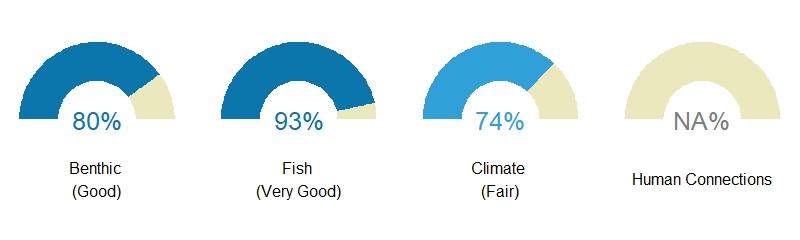
Data Interpretation:
The scores you see for each region are composite scores for the themes and then one overall score. The overall score is an average of all four theme scores for the Pacific Remote Islands region’s coral reef ecosystem score.
Benthic – Composite gauge for benthic theme score in the Pacific Remote Islands region is 80%, meaning it is ranked good with most indicators meeting reference values.
Fish – Composite gauge for fish theme score in the Pacific Remote Islands region is 93%, meaning it is ranked very good with all or almost all indicators meeting reference value.
Climate – Composite gauge for climate theme score in the Pacific Remote Islands region is 74%, meaning it is ranked fair with some indicators meeting reference values.
Human connections – Human connections theme was not scored for the Pacific Remote Islands region because the region is uninhabited.
Overall Ecosystem – Overall coral reef ecosystem score for the Pacific Remote Islands region is 82%, meaning it is ranked good with most indicators meeting reference values.
Description of each theme is provided in the indicator information section below.
Gauge values
90–100% Very good: All or almost all indicators meet reference values.
80–89% Good: Most indicators meet reference values.
70–79% Fair: Some indicators meet reference values.
60–69% Impaired: Few indicators meet reference values.
0–59% Critical: Very few or no indicators meet reference values.
Description of Pacific Remote Islands
The Pacific Remote Islands are a group of unincorporated US territories spread over hundreds of miles
in the Pacific Ocean. They consist of three islands, three atolls, and one reef, which are each national
wildlife refuges. These refuges make up the core of the Pacific Remote Islands Marine National
Monument. The Pacific Remote Islands data were divided into five sub-regions from Johnston atoll, Kingman reef and Palmyra atoll, Howland and Baker islands, Jarvis island, and Wake atoll. The total coral reef hardbottom habitat less than 30 m in depth that was monitored is 128 sq km
Gulf of America - Flower Garden Banks
The Flower Garden Banks coral reefs score 89, meaning most indicators meet reference values.

Description of gauge:
The Flower Garden Banks coral reefs score 89, meaning most indicators meet reference values.
Data Interpretation:
The scores you see for each region are composite scores for the themes and then one overall score. The overall score is an average of all four theme scores for the Flower Garden Banks region’s coral reef ecosystem score.
Benthic – Composite gauge for benthic theme score in the Flower Garden Banks region is 93%, meaning it is ranked very good with all or almost all indicators meeting reference values.
Fish – Composite gauge for fish theme score in the Flower Garden Banks region is 85%, meaning it is ranked good with most indicators meeting reference values..
Climate – Composite gauge for climate theme score in the Flower Garden Banks region is 88%, meaning it is ranked good with most indicators meeting reference values.
Human connections – Human connections theme was not scored for the Flower Garden Banks region because the region is uninhabited.
Overall Ecosystem – Overall coral reef ecosystem score for the Flower Garden Banks region is 89%, meaning it is ranked good with most indicators meeting reference values.
Description of each theme is provided in the indicator information section below.
Gauge values
90–100% Very good: All or almost all indicators meet reference values.
80–89% Good: Most indicators meet reference values.
70–79% Fair: Some indicators meet reference values.
60–69% Impaired: Few indicators meet reference values.
0–59% Critical: Very few or no indicators meet reference values.
Description of Gulf of America – Flower Garden Banks
The East and West Flower Garden Banks are submerged topographic features off the shores of Texas and Louisiana in the Gulf of Mexico. Rising from over 150 m depth to 17 m below the sea surface, they harbor relatively deep coral reef ecosystems. They were first discovered in the early 1900s and designated as part of the Flower Garden Banks National Marine Sanctuary in 1992. Flower Garden Banks combines data collected from both East and West Flower Garden Banks into a single score. The total coral reef hardbottom habitat less than 30 m in depth that was monitored for Flower Garden Banks is 0.898 square kilometers.
Florida
The Florida coral reefs score 69, meaning few indicators meet reference values.

Data Interpretation:
The scores you see for each region are composite scores for the themes and then one overall score. The overall score is an average of all four theme scores for the Florida region’s coral reef ecosystem score.
Benthic – Composite gauge for benthic theme score in the Florida region is 70%, meaning it is ranked fair with some indicators meeting reference values.
Fish – Composite gauge for fish theme score in the Florida region is 73%, meaning it is ranked fair with some indicators meeting reference values.
Climate – Composite gauge for climate theme score in the Florida region is 68%, meaning it is ranked impaired with very few indicators meeting reference values.
Human connections – Composite gauge for human connections theme score in the Florida region is 66%, meaning it is ranked impaired with very few indicators meeting reference values.
Overall Ecosystem – Overall coral reef ecosystem score for the Florida region is 69%, meaning it is ranked impaired with very few indicators meeting reference values.
Description of each theme is provided in the indicator information section below.
Gauge values
90–100% Very good: All or almost all indicators meet reference values.
80–89% Good: Most indicators meet reference values.
70–79% Fair: Some indicators meet reference values.
60–69% Impaired: Few indicators meet reference values.
0–59% Critical: Very few or no indicators meet reference values.
Description of Florida coral reefs
Florida’s coral reef extends from Martin County on the Atlantic Coast of Florida through the Keys to the Dry Tortugas in the Gulf of America. Florida’s coral reef is the only coral reef found along the coast of the continental United States. It was divided into three sub-regions to evaluate condition. The three regions are Southeast Florida, Florida Keys, and Dry Tortugas. The Dry Tortugas encompass a small group of islands approximately 67 miles west of Key West, Florida. Most of the Dry Tortugas lie within the National Park. The total coral reef hardbottom habitat less than 30 m in depth that was monitored is 1,190 sq km.
Puerto Rico
The Puerto Rico coral reefs score 70, meaning some indicators meet reference values.

Data Interpretation:
The scores you see for each region are composite scores for the themes and then one overall score. The overall score is an average of all four theme scores for the Puerto Rico region’s coral reef ecosystem score.
Benthic – Composite gauge for benthic theme score in the Puerto Rico region is 73%, meaning it is ranked fair with some indicators meeting reference values.
Fish – Composite gauge for fish theme score in the Puerto Rico region is 63%, meaning it is ranked impaired with very few indicators meeting reference values.
Climate – Composite gauge for climate theme score in the Puerto Rico region is 75%, meaning it is ranked fair with some indicators meeting reference values.
Human connections – Composite gauge for human connections theme score in the Puerto Rico region is 71%, meaning it is ranked fair with some indicators meeting reference values.
Overall Ecosystem – Overall coral reef ecosystem score for the Puerto Rico region is 70%, meaning it is ranked fair with some indicators meeting reference values.
Description of each theme is provided in the indicator information section below.
Gauge values
90–100% Very good: All or almost all indicators meet reference values.
80–89% Good: Most indicators meet reference values.
70–79% Fair: Some indicators meet reference values.
60–69% Impaired: Few indicators meet reference values.
0–59% Critical: Very few or no indicators meet reference values.
Description of Puerto Rico coral reefs
Puerto Rico is a volcanic island in the Greater Antilles located in the north central Caribbean between the US Virgin Islands to the east and the island of Hispaniola to the west. In addition to the main island, the islands of Mona, Monito, Desecheo, Caja de Muertos, Vieques, and Culebra make up the Commonwealth of Puerto Rico. Puerto Rico was not divided into sub-regions. The total coral reef hardbottom habitat less than 30 m in depth that was monitored is 994.5 sq km.
US Virgin Islands
The USVI coral reefs score 71, meaning some indicators meet reference values.
Data Interpretation:
The scores you see for each region are composite scores for the themes and then one overall score. The overall score is an average of all four theme scores for the US Virgin Islands region’s coral reef ecosystem score.
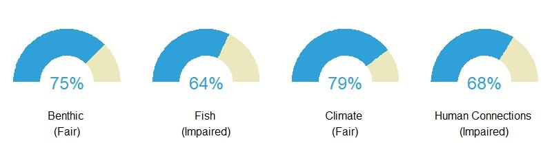
Benthic – Composite gauge for benthic theme score in the US Virgin Islands region is 75%, meaning it is ranked fair with some indicators meeting reference values.
Fish – Composite gauge for fish theme score in the US Virgin Islands region is 64%, meaning it is ranked impaired with very few indicators meeting reference values.
Climate – Composite gauge for climate theme score in the US Virgin Islands region is 79%, meaning it is ranked fair with some indicators meeting reference values.
Human connections – Composite gauge for human connections theme score in the US Virgin Islands region is 68%, meaning it is ranked impaired with very few indicators meeting reference values.
Overall Ecosystem – Overall coral reef ecosystem score for the US Virgin Islands region is 72%, meaning it is ranked fair with some indicators meeting reference values.
Description of each theme is provided in the indicator information section below.
Gauge values
90–100% Very good: All or almost all indicators meet reference values.
80–89% Good: Most indicators meet reference values.
70–79% Fair: Some indicators meet reference values.
60–69% Impaired: Few indicators meet reference values.
0–59% Critical: Very few or no indicators meet reference values.
Description of US Virgin Islands
The US Virgin Islands are an unincorporated territory located southeast of Florida between the Atlantic Ocean and Caribbean Sea. The territory consists of three major islands and many smaller islands, all surrounded by fringing coral reefs. The US Virgin Islands were divided into two subregions to evaluate condition. The two regions are St. Thomas/St. John and St. Croix. The total coral reef hardbottom habitat less than 30 m in depth that was monitored is 358 sq km.

Additional Resources
NOAA's National Coral Reef Monitoring Program
The NOAA Coral Reef Conservation Program established an integrated and focused monitoring effort with partners across the U.S.—the National Coral Reef Monitoring Program (NCRMP).

National Coral Reef Monitoring Program - Status Reports
NOAA's Coral Reef Conservation Program (CRCP) supports the National Coral Reef Monitoring Program (NCRMP) throughout the U.S. Pacific, Atlantic, Gulf of America, and Caribbean coral reef areas. This program is a strategic framework for conducting sustained observations of biological, climatic, and socioeconomic indicators in U.S. states and territories. The resulting data provide a robust picture of the condition of U.S. coral reef ecosystems and the communities connected to them.
A key component of this program is a periodic, national-level assessment on the status and trends of U.S. coral reef areas.

Coral Reef Watch Satellite Monitoring and Modeled Outlooks
For more than 20 years, NOAA Coral Reef Watch (CRW) has been using remote sensing, modeled, and in situ data to operate a decision support system (DSS) to help resource managers (our target audience), researchers, decision makers, and other stakeholders around the world prepare for and respond to coral reef ecosystem stressors, predominantly resulting from climate change and warming of the Earth's oceans.
Offering the world's only global early-warning system of coral reef ecosystem physical environmental changes, CRW remotely monitors conditions that can cause coral bleaching, disease, and death; delivers information and early warnings in near real-time to our user community; and uses operational climate forecasts to provide outlooks of stressful environmental conditions at targeted reef locations worldwide. CRW products are primarily sea surface temperature (SST)-based but also incorporate light and ocean color, among other variables.

Long-Term Monitoring at East and West Flower Garden Banks: 2019 Annual Report
This report summarizes fish and benthic community observations and water quality data collected from East Flower Garden Bank (EFGB) and West Flower Garden Bank (WFGB) in 2019, along with nearly 30 years of historical monitoring data. EFGB and WFGB are part of Flower Garden Banks National Marine Sanctuary (FGBNMS), located in the northwestern Gulf of America.

Florida Keys NMS Condition Report
Florida Keys National Marine Sanctuary is one of the largest marine protected areas in the United States, encompassing 2,896 square nautical miles (9,933 square kilometers). It was designated by Congress and exists under federal law, and became effective in state waters with the consent of the state of Florida. Marine zones for multiple uses, including 24 highly protected "no-take" areas (6% of the sanctuary), have been in place since 1997. The sanctuary helps protect more than 6,000 species of marine life, including the nation's only bank-barrier coral reef that lies adjacent to the continent, and one of the largest seagrass communities in this hemisphere. An estimated 400 underwater historical sites also lie within sanctuary waters, 14 of which are listed on the Department of the Interior's National Register of Historic Places.

Papahānaumokuākea Marine National Monument 2020 State of the Monument Report
Papahānaumokuākea Marine National Monument is the single largest conservation area under the U.S. flag, encompassing an area of 582,578 square miles of the Pacific Ocean—an area larger than all the country's national parks combined. Home to the highly endangered Hawaiian monk seal, threatened green turtles, and many species found nowhere else on earth, the complex and highly productive marine ecosystems of the monument are significant contributors to the biological diversity of the ocean.
